


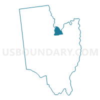
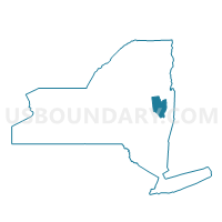
Voting District 040002, Saratoga County, New York
About
Outline

Summary
| Unique Area Identifier | 636413 |
| Name | Voting District 040002 |
| County | Saratoga County |
| State | New York |
| Area (square miles) | 10.56 |
| Land Area (square miles) | 10.22 |
| Water Area (square miles) | 0.34 |
| % of Land Area | 96.80 |
| % of Water Area | 3.20 |
| Latitude of the Internal Point | 43.22035690 |
| Longtitude of the Internal Point | -73.79208710 |
Maps

Graphs
Select a template below for downloading or customizing gragh for Voting District 040002, Saratoga County, New York


Neighbors
Neighoring Voting District (by Name) Neighboring Voting District on the Map
- Voting District 040003, Saratoga County, NY
- Voting District 040005, Saratoga County, NY
- Voting District 080003, Warren County, NY
- Voting District 080005, Saratoga County, NY
- Voting District 140005, Saratoga County, NY
- Voting District 210009, Saratoga County, NY
Top 10 Neighboring County Subdivision (by Population) Neighboring County Subdivision on the Map
- Wilton town, Saratoga County, NY (16,173)
- Moreau town, Saratoga County, NY (14,728)
- Greenfield town, Saratoga County, NY (7,775)
- Corinth town, Saratoga County, NY (6,531)
- Lake Luzerne town, Warren County, NY (3,347)
Top 10 Neighboring Place (by Population) Neighboring Place on the Map
Top 10 Neighboring Unified School District (by Population) Neighboring Unified School District on the Map
- South Glens Falls Central School District, NY (19,546)
- Corinth Central School District, NY (7,576)
- Hadley-Luzerne Central School District, NY (6,585)
Top 10 Neighboring State Legislative District Lower Chamber (by Population) Neighboring State Legislative District Lower Chamber on the Map
- Assembly District 112, NY (139,495)
- Assembly District 110, NY (138,331)
- Assembly District 113, NY (135,737)
Top 10 Neighboring State Legislative District Upper Chamber (by Population) Neighboring State Legislative District Upper Chamber on the Map
- State Senate District 43, NY (322,103)
- State Senate District 44, NY (317,410)
- State Senate District 45, NY (306,856)
Top 10 Neighboring 111th Congressional District (by Population) Neighboring 111th Congressional District on the Map
Top 10 Neighboring Census Tract (by Population) Neighboring Census Tract on the Map
- Census Tract 607.01, Saratoga County, NY (7,078)
- Census Tract 601.01, Saratoga County, NY (6,199)
- Census Tract 603, Saratoga County, NY (3,972)
- Census Tract 710, Warren County, NY (3,347)
- Census Tract 606.01, Saratoga County, NY (2,715)
- Census Tract 604, Saratoga County, NY (2,559)